

What Your Ground Team is Missing: How 3D Mapping Prevents Six-Figure Mistakes
A single miscalculation in grading. A stockpile that’s twenty percent larger than estimated. A concrete pour scheduled for a site that isn't actually level.
In the world of construction and site development, these aren't just "hiccups." They are six-figure disasters waiting to happen. Most site managers rely on ground-level inspections and manual surveying to catch these errors. But the truth is, even the most experienced ground team has blind spots. When you are standing in the dirt, you are limited by perspective, human error, and the sheer scale of the project.
At SKYVISION, we don’t just provide "cool drone shots." We provide Operational Intelligence.
By leveraging high-resolution 3D mapping and advanced data services, we give project managers "X-ray vision" over their entire site. We turn raw acreage into actionable data that prevents rework, secures timelines, and protects your bottom line.
The Blind Spots of Traditional Site Management
Traditional site monitoring often involves "walking the line." A foreman or inspector traverses the site, taking photos and checking measurements against the blueprints. While essential, this method is fundamentally flawed for three reasons:
Fragmented Data: You’re looking at pieces of the puzzle, not the whole image.
Human Subjectivity: Two inspectors might see two different things.
Static Documentation: By the time a manual report is filed, the site has already changed.
When you miss a detail at the ground level, the cost of fixing it grows exponentially as the project progresses. This is where drone mapping and data services bridge the gap between "hoping it's right" and "knowing it's right."
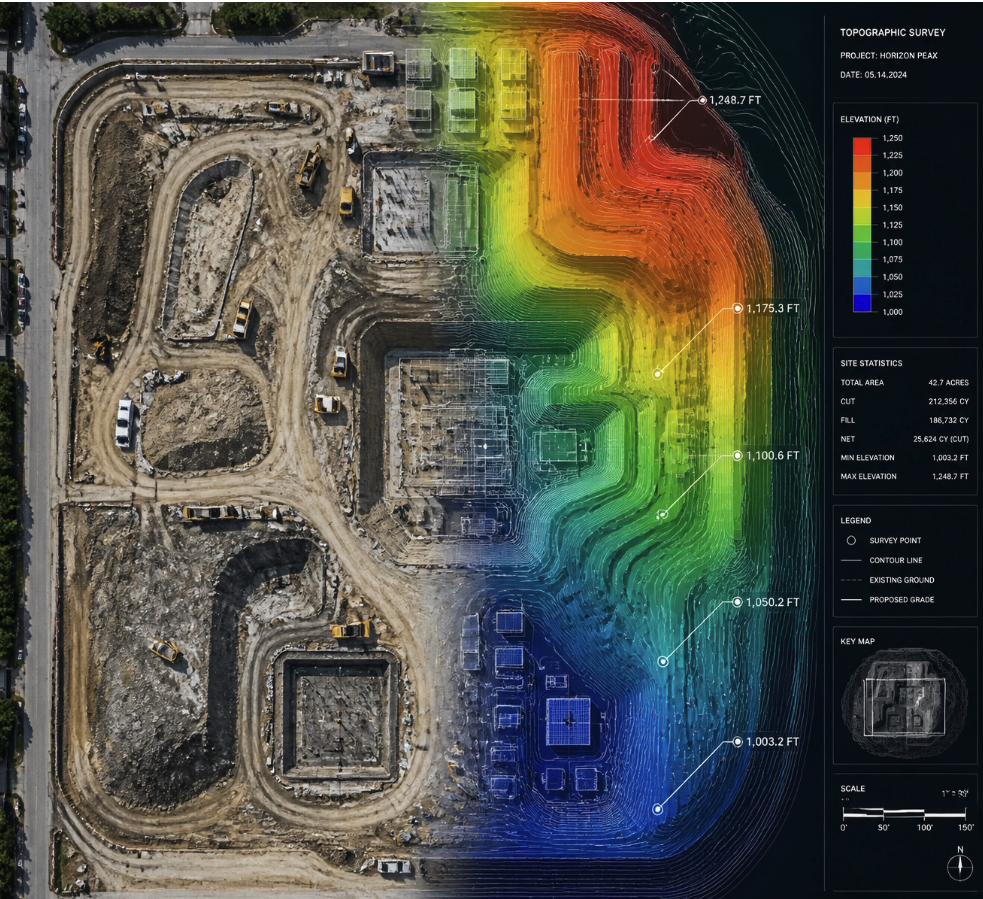
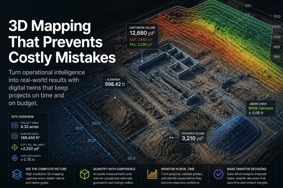
High-Resolution Orthomosaics: The Digital Foundation of Truth
The first layer of operational intelligence is the High-Resolution Orthomosaic Map. Unlike a standard aerial photo, an orthomosaic is a geometrically corrected map where every pixel contains data. It is a top-down, distortion-free "digital twin" of your site.
For general contractors, this is the ultimate source of truth. You can zoom in to see individual pieces of rebar or zoom out to see how the entire site relates to the surrounding infrastructure.
Measurable Accuracy: You can measure distances, areas, and perimeters directly on the map with centimeter-grade precision.
Overlay blue-prints: We can overlay your CAD drawings directly onto the real-world map to see exactly where the site deviates from the plan.
Instant Verification: Did the land clearing team hit the exact boundaries? The map doesn't lie.
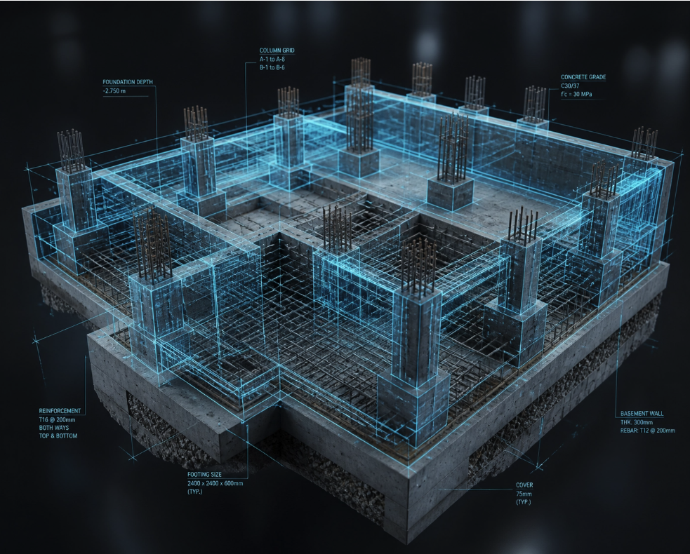
3D Models: Visualizing the Future (and the Flaws)
Static maps are great, but 3D models are transformative. Using photogrammetry, SKYVISION creates immersive 3D digital twins of your project. This allows stakeholders to rotate, tilt, and fly through a digital version of the job site from their office in Brevard County or even from a headquarters halfway across the country.
Why this prevents six-figure mistakes:
Imagine you are managing a massive commercial build. The 3D model reveals that a trench is being dug three feet off-center from the utility lines. On the ground, it looks fine. In the 3D model, the error is glaring. Catching that on Day 4 instead of Day 40 saves you the cost of a full excavation rework and potentially weeks of delays.
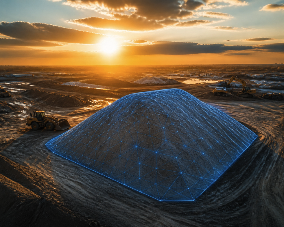
Volume Calculations: The Profit Is in the Dirt
One of the most common ways money "leaks" out of a construction site is through earthwork. If you are paying for soil removal or fill based on estimates, you are likely overpaying.
SKYVISION’s drone data allows for instant, accurate Volume Calculations. We can tell you exactly how many cubic yards are in a stockpile or how much earth needs to be moved to reach the finished grade.
Audit Subcontractors: Ensure you are only paying for the volume actually moved.
Resource Allocation: Know exactly how many trucks you need, reducing idle time and fuel costs.
Progress Tracking: Compare volume data week-over-week to see exactly how much work has been completed.
This level of precision is especially critical for pool builders and specialized paving projects where every inch of slope matters.
Progress Tracking: The Accountability Engine
A project is only as good as its last update. SKYVISION provides scheduled aerial data capture that acts as a visual timeline of your project’s evolution.
When you have a chronological record of high-res maps and 3D models, you create a "Visual Authority" that keeps everyone accountable.
Resolve Disputes: If a subcontractor claims they finished a phase by Friday, you have the dated, high-res proof.
Stakeholder Confidence: Send your investors or clients a link to the latest 3D model. It builds a level of trust that a simple email update never could.
Early Intervention: Identify bottlenecks before they stall the entire project.
We don't just capture footage; we capture market share by ensuring your projects are finished faster and with fewer errors than your competitors.
The SKYVISION Edge: More Than a Vendor, a Growth Partner
Many "drone pilots" can fly a loop around a site and give you a video. SKYVISION is different. We operate as a strategic marketing and data partner.
We understand that for firms in St. Lucie and Indian River counties, the goal isn't just to see the site: it's to win the next contract. Using the data we capture, you can show potential clients exactly how you manage sites with surgical precision. It transforms your brand from a "builder" to a "technology-driven industry leader."
Our inspection services and data workflows are designed to integrate seamlessly into your existing project management software. We translate complex aerial data into simple, actionable insights that your ground team can use immediately.
Serving Florida, Preparing for the Nation
Currently, SKYVISION is the premier partner for construction and site development firms across Brevard, Indian River, and St. Lucie counties. We know the local terrain, the coastal challenges, and the high standards of Florida site management.
However, our vision is larger. As we prepare for national expansion, our commitment remains the same: providing the Visual Authority and Operational Intelligence that allows businesses to scale without the fear of expensive, avoidable mistakes.
Stop Guessing. Start Mapping.
If your ground team is relying on traditional methods alone, you are leaving your profit margins to chance. A $500 drone mission can prevent a $500,000 mistake. The ROI isn't just in the photos: it's in the certainty.
Are you ready to see what you've been missing? Don't wait for the next rework order to realize you need a better view.
Book a Strategy Session with the SKYVISION team today and let’s secure your site’s future.
Stay sharp,
The SKYVISION Team